
Flock & ALPR cameras, mapped.
Find cameras for free. Avoid them with BanditKin. Type a city below to see every mapped ALPR camera near you — and which way each one faces.
Want the app that routes around these cameras?
Thanks — if that's the email you use on Google Play, we'll add you to the Android test within a day. Otherwise we'll email you when the public release lands.
Message us cameras to add, corrections, or requests.
From the BanditKin app
Don't just see the cameras. Route around them.
BanditKin's private navigation is built on this same camera data. Plan a drive and it can steer you around the ALPR cameras it knows about — turn by turn, entirely on your device.
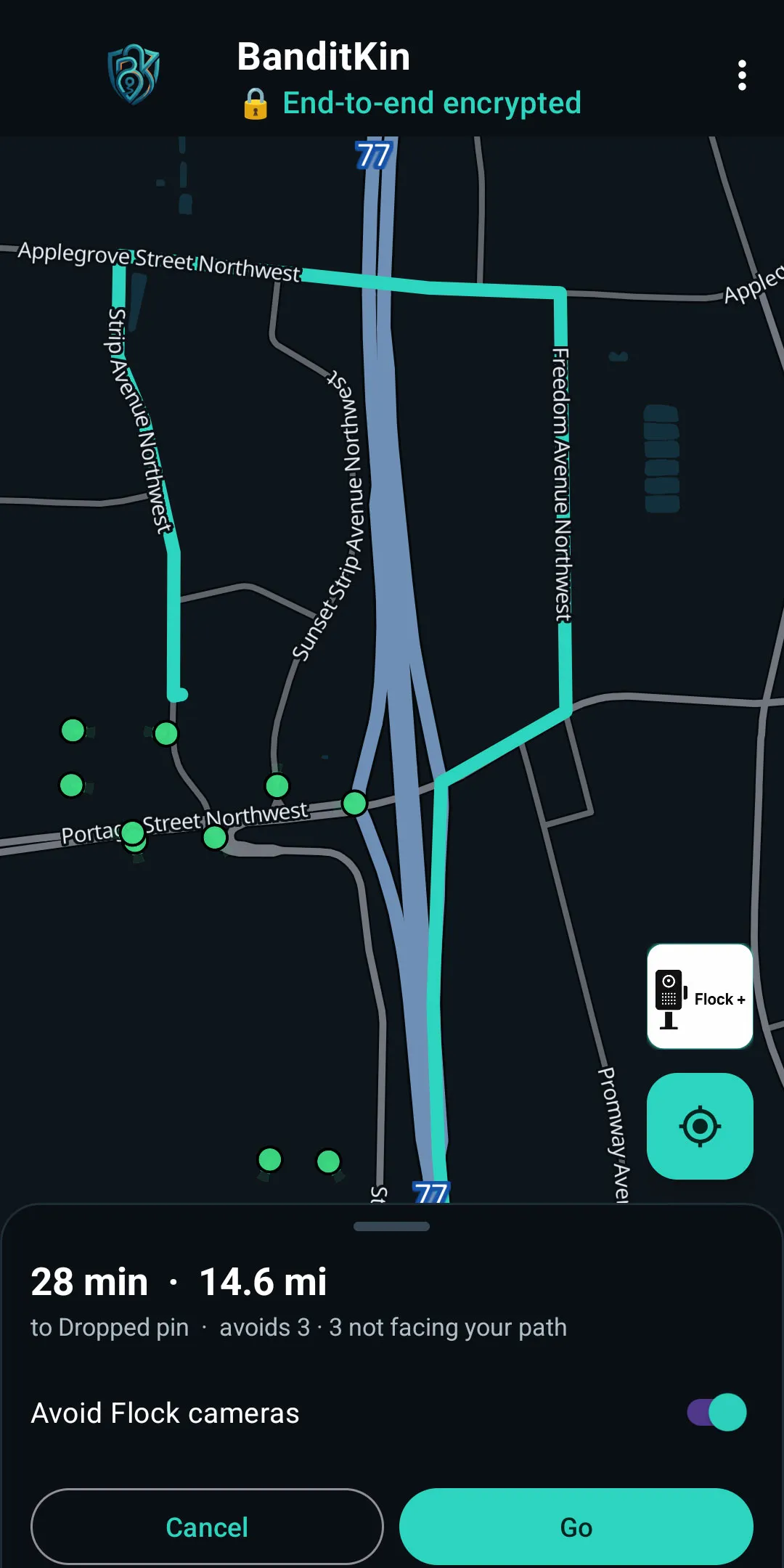
Avoidance, built into navigation
Switch on Avoid Flock and BanditKin steers your route around the ALPR cameras it knows about — using each camera's field of view, so it only detours when your path would actually cross a camera's view, not when you'd pass behind it. A strength slider sets how wide a berth to give, and if no camera-free route exists it falls back to the normal one. The avoidance is computed on your phone; your route isn't sent to the camera service. It's a privacy choice — avoid being logged by a commercial surveillance network, using public camera data.
See how private navigation works →It only detours when you'd actually be seen
The route preview says it plainly: "avoids 5 · 6 not facing your path." Cameras aimed away from your route don't trigger a detour — only ones whose approximate field of view your path would cross.
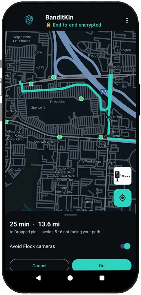
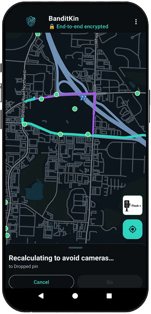
Recalculates around cameras as you drive
Miss a turn and BanditKin recalculates to avoid cameras on the new path — computed on your phone, with your route never sent to the camera service.
Honest when one can't be avoided
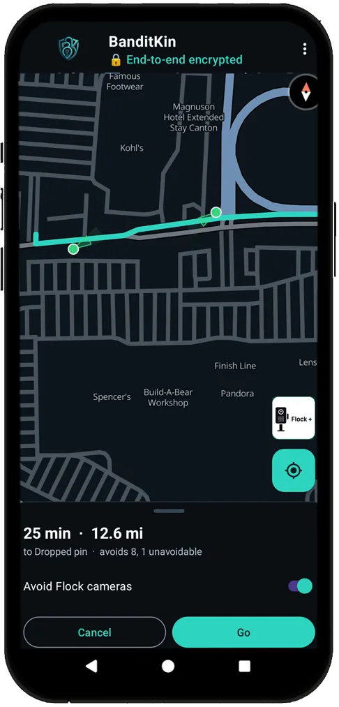
"Avoids 8, 1 unavoidable." When there's no camera-free way through, BanditKin says so and takes the best route anyway — it never pretends, and it never strands you.
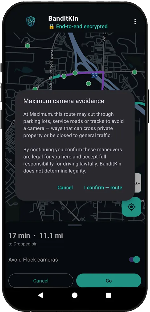
Maximum avoidance asks first
At the top of the Aggressive Routing slider, a route may use parking lots or service roads. Before it does, you confirm those maneuvers are legal where you are — BanditKin doesn't determine legality; the driver is responsible.
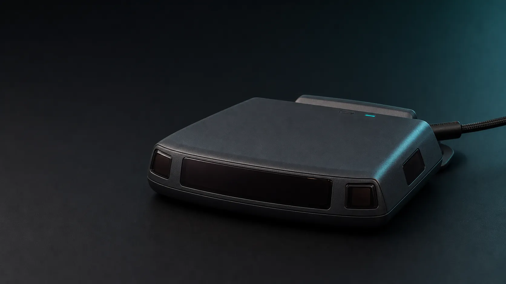
Beyond the plate: meet Sentinel.
Roadside sensing is moving past the license plate. BanditKin Sentinel is a receive-only USB-C accessory — in development and in-house testing — designed to flag supported roadside sensor activity and help you document it. It doesn't jam or identify a specific vendor from a signal.
What are Flock and ALPR cameras?
An automated license-plate reader (ALPR) is a camera paired with software that photographs passing vehicles and reads their license plates. Each read is typically logged with the plate number, a timestamp, the camera's location, and often a photo of the vehicle. Flock Safety is the most widely deployed vendor in the United States; other vendors include Motorola Solutions (Vigilant) and Genetec.
Plate number, date and time, and location of each passing vehicle. Many systems also record a “vehicle fingerprint” — make, type, color, and distinguishing features — even when a plate isn't readable.
As fixed units on poles and at intersections, or as mobile units mounted on vehicles. Reads are stored in searchable databases, and some vendors let agencies share data across a wider network.
Locating stolen or wanted vehicles, supporting criminal investigations and AMBER or Silver alerts, neighborhood and HOA security, and access, toll, or parking enforcement.
Law enforcement agencies, homeowner associations and neighborhoods, and private businesses. Retention periods for stored reads vary by operator and jurisdiction.
What you're looking at
Each pin is a camera location with a confidence score. Here's how to use it.
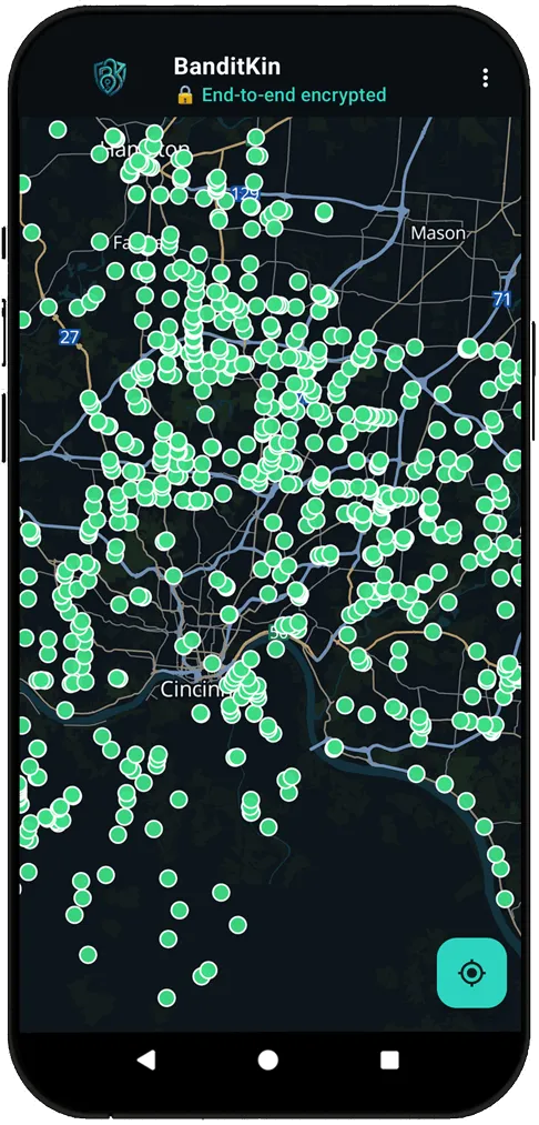
Green pins are verified or confirmed, amber are listed or corroborated, and red are newly reported and least certain.
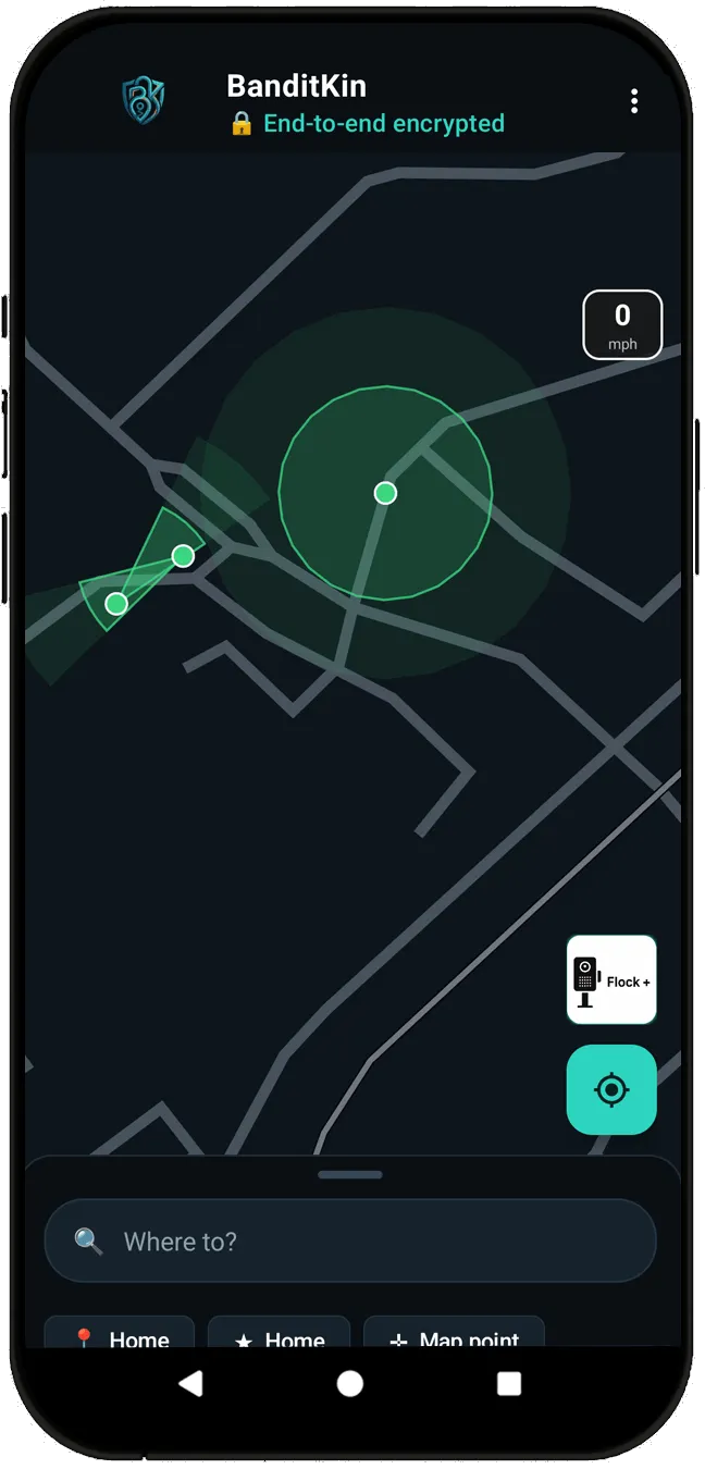
Zoom in and each camera shows its approximate capture zone — the direction it faces, drawn as a translucent wedge, with 360° cameras shown as a circle (about a 75-foot read range). See at a glance which side of the road a camera reads.
Toggle Flock, Motorola / Vigilant, Genetec, other, or untagged cameras from the menu to focus the view.
Tap any camera to see its vendor, operator, the agencies that run ALPR in that area (via the EFF Atlas), and the source record on OpenStreetMap.
Spotted a camera? Add it. Confirm or dispute existing ones with “still here / gone.” Reports are reviewed before they go public.
Where the data comes from
Locations come from public records and verified community reports. Nothing here is private data.
The location source of truth — roughly 336,000 mapped ALPR cameras, openly licensed and editable by anyone.
Cross-references which agencies operate ALPR and which vendor they use, for jurisdiction-level coverage context.
New and updated pins, validated by independent confirmations and drive-by corroboration before they appear.
Questions about the camera map
What is an ALPR or Flock camera?
An automated license-plate reader (ALPR) photographs every passing vehicle's plate, along with the time and location. Flock Safety is the most common vendor in the US; others include Motorola / Vigilant and Genetec.
How accurate are the camera locations?
Pins come from OpenStreetMap — the openly maintained location source of truth — plus community reports that are confirmed by multiple independent users before they appear. Each pin carries a confidence score.
Is this affiliated with Flock Safety or law enforcement?
No. BanditKin is not affiliated with Flock Safety, any camera vendor, or any agency. It is a privacy-transparency tool that documents public infrastructure using public data.
Does using this map share my location?
No. Browsing the map sends nothing identifying. “Near me” uses your device location only to center the map, and any camera report you submit is anonymous — tagged with a random ID, never your identity.
Can I add a camera I've seen?
Yes. Tap the map to report one. New reports stay hidden until they're corroborated by other users or approved, so the public map stays accurate.
Which direction does a Flock camera face?
Zoom into any camera and the map draws its approximate viewing cone — the direction it faces and its capture zone, shown as a translucent wedge (360° cameras show a circle). The direction comes from public map data; the field of view is an approximate, best-case illustration, not an exact measurement.
How far can an ALPR camera read a license plate?
Roughly 75 feet for a typical fixed camera — that's what the viewing cones on the map illustrate. It's an approximate range that varies with the camera, lens, angle, and conditions, so treat the cone as a guide rather than a precise boundary.
Can I route around Flock cameras?
In the BanditKin app, yes. Turn on Avoid Flock and it plans a route around the ALPR cameras it knows about, using each camera's field of view so it only detours when your path would actually cross a camera's view. A slider sets how wide a berth to give, and if no camera-free route exists it falls back to the normal one — computed on your device, as a privacy preference to avoid being logged by a commercial surveillance network.
Want this map in your pocket?
BanditKin puts this same camera map — plus optional Avoid Flock routing — in a private, end-to-end-encrypted app. Leave your email and we'll tell you the moment it launches, on Android or iPhone.
Thanks — if that's the email you use on Google Play, we'll add you to the Android test within a day. Otherwise we'll email you when the public release lands.
Data: © OpenStreetMap contributors (ODbL) · coverage © EFF Atlas of Surveillance (CC-BY) · plus community-contributed reports. BanditKin is not affiliated with Flock Safety, any vendor, or any agency.
ALPR camera maps by city
Dedicated maps for 75 metros — each opens on that city with its mapped camera count, the agencies and vendors behind them, which way the cameras face, and the programs on public record.
Akron, OH · Albuquerque, NM · Allentown, PA · Athens, GA · Atlanta, GA · Augusta, GA · Aurora, IL · Austin, TX · Baton Rouge, LA · Birmingham, AL · Boston, MA · Buffalo, NY · Charlotte, NC · Chicago, IL · Cincinnati, OH · Cleveland, OH · Columbus, OH · Dallas, TX · Dayton, OH · Denver, CO · Detroit, MI · Flint, MI · Fort Worth, TX · Fresno, CA · Greenville, SC · Hartford, CT · Houston, TX · Indianapolis, IN · Jacksonville, FL · Kansas City, MO · Knoxville, TN · Las Vegas, NV · Lexington, KY · Little Rock, AR · Los Angeles, CA · Louisville, KY · Macon, GA · Memphis, TN · Miami, FL · Milwaukee, WI · Murfreesboro, TN · Nashville, TN · New Haven, CT · New Orleans, LA · New York, NY · Oklahoma City, OK · Orlando, FL · Philadelphia, PA · Phoenix, AZ · Pittsburgh, PA · Providence, RI · Provo, UT · Raleigh, NC · Richmond, VA · Riverside, CA · Rockford, IL · Sacramento, CA · Saint Paul, MN · Salt Lake City, UT · San Antonio, TX · San Diego, CA · San Francisco, CA · San Jose, CA · Savannah, GA · Seattle, WA · St. Louis, MO · Stamford, CT · Tampa, FL · Toledo, OH · Trenton, NJ · Tucson, AZ · Tulsa, OK · Virginia Beach, VA · Washington, DC · Wichita, KS
Flock & ALPR cameras by state
Every state has its own page: 141,963 mapped ALPR cameras across all 50 states as of 3 September 2026, each counted inside the state boundary rather than by metro box. Open a state for its largest operators, vendor mix, direction coverage and city-by-city counts.
2,782 cameras
22 cameras
2,857 cameras
1,218 cameras
20,917 cameras
2,849 cameras
994 cameras
446 cameras
9,640 cameras
9,909 cameras
52 cameras
492 cameras
7,301 cameras
3,753 cameras
985 cameras
2,126 cameras
1,937 cameras
2,031 cameras
71 cameras
1,010 cameras
1,237 cameras
3,802 cameras
1,727 cameras
1,086 cameras
3,499 cameras
68 cameras
565 cameras
930 cameras
77 cameras
2,244 cameras
1,000 cameras
4,762 cameras
3,703 cameras
209 cameras
7,012 cameras
1,543 cameras
621 cameras
3,384 cameras
326 cameras
2,064 cameras
216 cameras
3,592 cameras
16,830 cameras
1,155 cameras
33 cameras
3,437 cameras
2,442 cameras
254 cameras
2,296 cameras
457 cameras
State totals are polygon counts and can be compared with each other; city figures on the pages above are bounding-box reads and cannot. Every number is a floor — cameras appear on the map as people map them.